
Overview
Phygimap represents our approach to tangible interaction design—bridging the tactile immediacy of physical objects with the dynamic possibilities of digital media. It's an interactive installation platform where physical maps become control surfaces for synchronized digital experiences.
Users interact naturally with physical elements—touching, placing tokens, manipulating objects—while digital projections respond in real-time, creating magical moments where the boundary between physical and digital dissolves.
The platform is ideal for museums, exhibitions, educational spaces, and brand experiences where intuitive, multi-user interaction creates engagement impossible with traditional screens.
Key Features
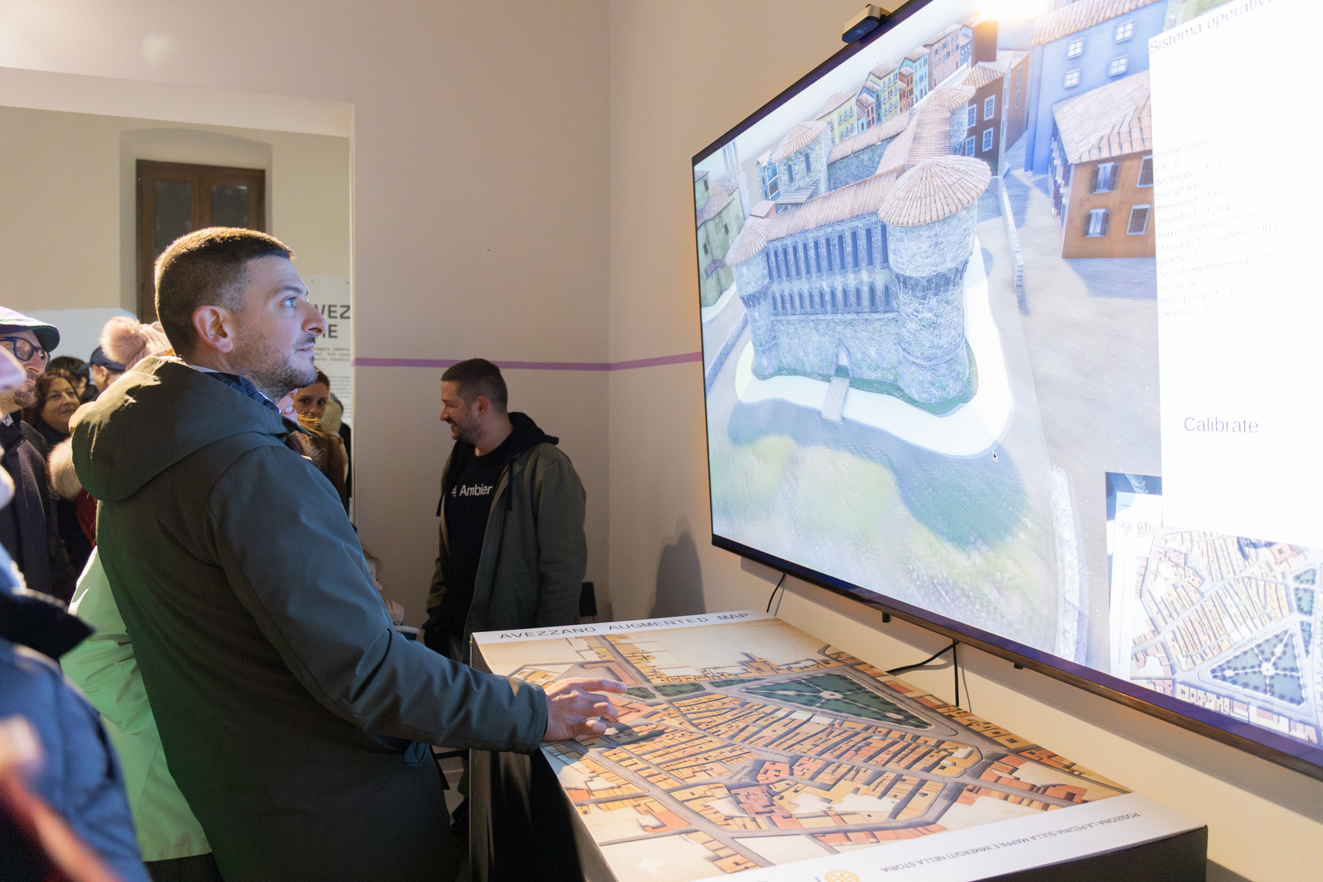
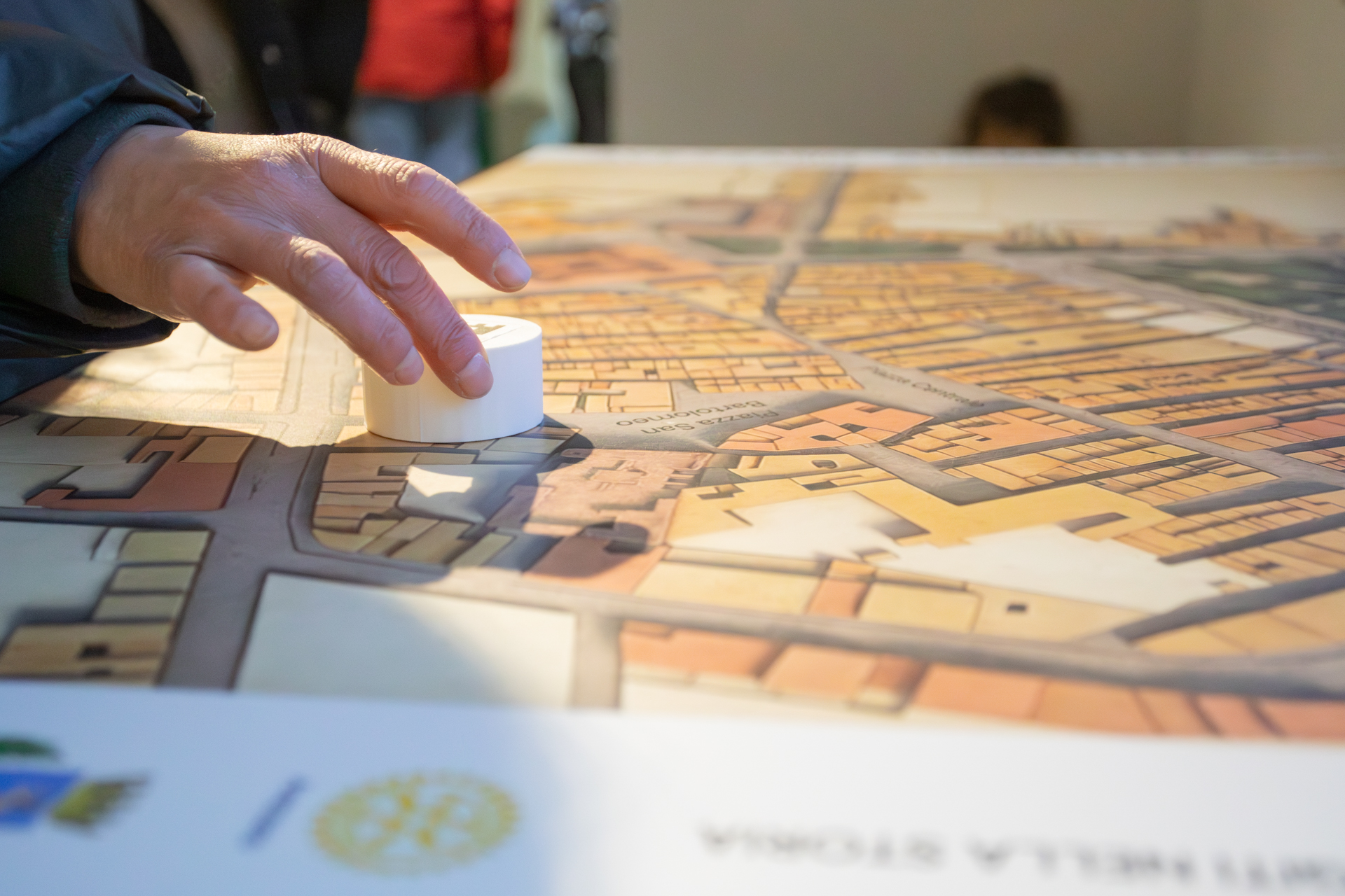
The Phygimap @Avezzano che fu permanent installation (photo by panamamedia.it/)
Tangible Interaction
Physical tokens, knobs, and surfaces serve as intuitive controls. No screens to touch, no menus to navigate—interaction feels natural and immediate. Multiple users can interact simultaneously without conflict.
Real-time Projection Mapping
High-precision projection calibration ensures digital content aligns perfectly with physical surfaces. Dynamic content responds instantly to user actions, creating seamless phygital experiences.
Computer Vision Tracking
Custom vision systems detect object positions, movements, and gestures. Robust tracking works in varied lighting conditions with automatic recalibration.
Spatial Audio
Directional audio reinforces spatial narrative. Sound sources appear to emanate from physical locations on the map, enhancing immersion and wayfinding.
Modular Design
Components adapt to different map scales and content types. From tabletop installations to room-scale experiences, the system scales to project needs.
Technical Architecture
Vision System
Multiple cameras track interaction surface using infrared or visible light. Custom computer vision algorithms process images in real-time, detecting objects, gestures, and user positions.
Control Software
Unity-based application manages all interactions. Modular content system allows easy updates without changing physical installation. Remote monitoring and diagnostics ensure uptime.
Interaction Patterns
Token Placement
Physical tokens represent points of interest, time periods, or narrative elements. Place tokens on the map to reveal content, compare scenarios, or activate storytelling.
Multi-user Collaboration
Multiple people interact simultaneously. The system tracks individual actions while orchestrating coherent collective experience.
Use Cases
Museum Exhibitions
Historical maps come alive with layered information. Visitors explore how cities changed over time, understand historical events in spatial context, engage with stories anchored to real places.
Urban Planning
Stakeholders interact with proposed developments. Place physical building blocks to test scenarios, adjust parameters to see impacts, collaborate on shared vision for urban futures.
Education
Geography, history, and science become tangible. Students manipulate physical elements to explore concepts, test hypotheses, and discover spatial relationships through hands-on learning.
Brand Experiences
Product launches and showrooms use interactive maps to tell brand stories. Visitors explore manufacturing locations, understand supply chains, connect with brand heritage through spatial narratives.
Cultural Heritage
Archaeological sites and historical locations documented at scale. Visitors "excavate" layers of history, compare past and present, understand cultural evolution through tangible interaction.
Tourism & Wayfinding
Destination exploration in hotels, visitor centers, or public spaces. Tourists plan routes, discover attractions, access information through intuitive spatial interface.
Content Management
Timeline Systems
Scrub through historical periods with physical timeline control. Digital projection shows map evolution, buildings appear and disappear, boundaries shift across centuries.
Data Visualization
Physical layer selectors activate different data overlays. Population density, traffic patterns, environmental data—complex information becomes spatially comprehensible.
Narrative Engines
Branching storylines triggered by token placement. Characters move across the map, events unfold in spatial sequence, users co-author narratives through their choices.
Media Integration
Videos, images, and audio triggered by interaction. Content appears contextualized at relevant map locations, creating rich multimedia experiences.
Design Principles
Natural Affordances
Physical design communicates functionality without labels. If it looks like you can touch it, you can—and something interesting will happen.
Immediate Feedback
Digital response occurs within 100ms of physical action. This temporal coupling creates sense of direct manipulation rather than indirect control.
Fault Tolerance
System gracefully handles unexpected interactions. No error states, no breaking the experience—every action produces meaningful response.
Accessibility
Physical interaction accommodates different abilities. Heights adjustable for wheelchair access, audio descriptions available, tactile and visual feedback redundancy.
Case Studies
Avezzano che fu
Interactive XR installation combining physical token placement with digital screen, revealing historical city before 1915 earthquake. Phygimap technology enabled intuitive exploration of lost urban fabric.
Have an idea for an event or installation?
Contact us to discuss integrating our phygimap system into your next event, brand activation, or exhibition.